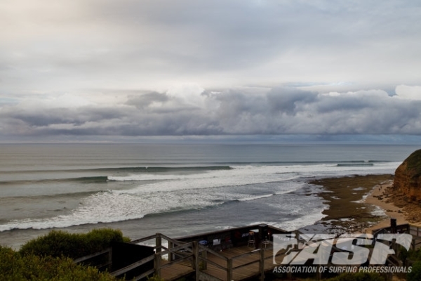
Bells Beach – one of the most iconic lineups on the planet.
BELLS BEACH, Victoria/AUS (Tuesday, March 26, 2013) – The Rip Curl Pro Bells Beach presented by Ford, Stops No. 2 and 3 respectively on the men’s and women’s 2013 ASP World Championship Tours (WCT), will commence its competition window tomorrow, March 27, and initial swell outlooks are promising for the coming week.
CoastalWatch, official surf forecasters for the Rip Curl Pro Bells Beach, have provided the following update for the event:
To sum up the forecast in one short sentence; it’s going to pump. Although the first few days of the waiting period are a little on the small side and a little inconsistent, the Easter long weekend is shaping up as nothing short of excellent.
Wednesday 27 March: New mid period SW groundswell 1 to 2ft early, building to 2 to 3ft at Bells during the late afternoon. WIND: WNW 5 to 15 knots tending to sea-breezes during the afternoon.
Thursday 28 March: Leftover SW swell around 2ft+ at Bells. New long range WSW groundswell building to an inconsistent 2 – 4ft at Bells during the afternoon. WIND: WSW 15 to 20 knots.
Friday 29 March: SW groundswell, 3 to 5ft at Bells. WIND: WNW 10 to 15 knots, tending to sea breezes later.
Saturday 30 March: SW groundswell around 3 – 4ft+ at Bells, building to an inconsistent 4 – 5ft during the late afternoon/ evening. WIND: WNW 10 to 15 knots, tending to sea breezes later.
Sunday 31 March: SW groundswell 5 – 6ft+ at Bells. WIND: Light to moderate WNW to WSW.
Monday 1 April: SW groundswell 4 to 5ft at Bells, easing later. WIND: Light NW to NE winds, 5 to 10 knots tending N during the afternoon.
Forecast Overview
Small wind affected SW swell on Wednesday, rising during the day
Northerly winds develop ahead of a pre-frontal trough and cold front crossing the Bight on Tuesday before approaching western Bass Strait on Wednesday morning. NNW winds are set to increase in strength ahead of the front, probably adding some chop up the face at Bells. At the same time a slight rising trend in mid period SW swell sets in throughout Wednesday afternoon, arising from complex low set up over polar latitudes, deep beneath Western Australia over the weekend.
Smaller leftover SW swell on Thursday precedes a late increase in WSW groundswell
The tail end of Wednesday’s pulse drops to lower levels on Thursday; around two to three feet at Bells but inconsistent in the upper range. Thursday afternoon also marks the arrival of a new WSW groundswell gradually building in across the region. This long period episode is now expected to fill in a little later than last week’s model runs suggested, so any substantial increase probably won’t show until later in the afternoon or evening. Thursday also sees a steep increase in WSW windswell generated by a vigorous cold front crossing Bass Strait during the day, but the short intervals and westerly swell direction should ensure most of this energy by-passes the Surf Coast.
The swell source is a complex area of low pressure that formed over Polar latitudes, south-west of the Kerguelen Islands over the weekend. The storm set up an extensive, albeit fragmented belt of WSW gales across the 50S to 60S latitudinal bands, giving rise to a maximum significant wave height of 25 to 30 feet over the Southern Ocean on Sunday. The system began to weaken out as it moves into Western Australian longitudes on Monday and the SW fetch will substantially peter out by Tuesday.
Although the vast distance of the swell source from the Victorian coast exacerbates wave decay and dispersion, it’s a second polar frontal low feeding into this first low beneath Western Australia that holds stronger SW swell potential for Friday. The system capitalises on the pre-existing sea state generated by the parent low, carrying a strong to gale force SW fetch up into the Great Australian Bight. The system rapidly regenerates seas and swell to a maximum of about 25 feet beneath WA on Wednesday morning.
The shorter distance of this second system from Victoria facilitates a more consistent four foot pulse at Bells on Friday, but there’s still some uncertainty regarding local winds. Some latest model runs lean towards lighter WNW winds prevailing in the wake of Thursday’s cold front. Only the EC model suggests the change will arrive later Thursday, thereby maintaining strong WSW winds across the region early Friday – this will become clearer over the next few days.
Strong SW groundswell arrives over the Easter long weekend: The active storm track affecting Victoria’s swell window is supported by a high pressure system anchored over the south-eastern Indian Ocean that’s funneling a succession of polar fronts and lows up beneath Western Australia. This activity comes to a head as a deep polar low develops over the Southern Ocean, south-east of the Kerguelen Islands on Tuesday.
Deep low intensifies Wednesday and Thursday: Although some recent US model runs have slightly delayed the development of the low, they are all consistently intensify the low as it tracks steadily eastward throughout Wednesday and Thursday, setting up a deep belt of WSW gale to storm force winds across its upper flank. The fetch moves roughly at the same pace and in the same direction as the swell being generated – a process know as Captured Fetch- compounding the size of the resulting deepwater swell. This is reflected in latest WW3 runs that are now picking up 30 to 40ft seas and swell carried towards Victoria in line with the low’s eastward track beneath Western Australia on Thursday.
The leading edge of a long interval SW groundswell is projected to make landfall across Victoria later Saturday; at this stage triggering a steep increase in wave height at Bells Beach throughout the afternoon. This energy is forecast to peak on Sunday at a solid five to six foot plus at Bells. Further, it’s likely to be closely followed by a second, strong pulse on Monday, following a trailing frontal low intensifying dramatically about 1,500 nautical miles south-west of Bass Strait on Saturday. This hints at a strong follow up pulse on Monday in the six foot range, but it’s still too early to call this with confidence.
Beyond that, the fringes of some latest computer models pick up another intense extra-tropical low tracking across our long range swell window, deep beneath Western Australia over the Easter long weekend. This also holds excellent potential for another large pulse of more favourable aligned SSW groundswell arriving throughout Tuesday 2 and peaking early Wednesday 3 April. This is still considered speculative and revisions are likely over the course of the week.
Event organizers will convene tomorrow morning at 6:30am to assess conditions for a possible 8am start.
The 2013 Rip Curl Pro Bells Beach will be webcast LIVE via www.live.ripcurl.com and broadcast live on Fuel TV in Australia and Portugal, ESPN in Brazil and MCS Extreme in France, Luxembourg, Belgium, Switzerland and Africa. You can also watch the event live via the Rip Curl Pro iPhone app, available free in the iTunes App Store.
RIP CURL PRO BELLS BEACH ROUND 1 MATCH-UPS:
Heat 1: Gabriel Medina (BRA), Matt Wilkinson (AUS), Raoni Monteiro (BRA) Heat 2: Julian Wilson (AUS), Kai Otton (AUS), Patrick Gudauskas (USA) Heat 3: Taj Burrow (AUS), Kieren Perrow (AUS), Willian Cardoso (BRA) Heat 4: Mick Fanning (AUS), Sebastian Zietz (HAW), Oney Anwar (IDN) Heat 5: Joel Parkinson (AUS), Brett Simpson (USA), Jack Perry (AUS) Heat 6: Kelly Slater (USA), Adam Melling (AUS), Jacob Wilcox (AUS) Heat 7: Adriano de Souza (BRA), Alejo Muniz (BRA), Tiago Pires (PRT) Heat 8: Josh Kerr (AUS), Damien Hobgood (USA), Dusty Payne (HAW) Heat 9: Jeremy Flores (FRA), Travis Logie (ZAF), Nat Young (USA) Heat 10: Michel Bourez (PYF), Bede Durbidge (AUS), Filipe Toledo (BRA) Heat 11: Owen Wright (AUS), Adrian Buchan (AUS), Glenn Hall (IRL) Heat 12: Jordy Smith (ZAF), C.J. Hobgood (USA), Kolohe Andino (USA)
RIP CURL WOMEN’S PRO BELLS BEACH ROUND 1 MATCH-UPS:
Heat 1: Courtney Conlogue (USA), Laura Enever (AUS), Silvana Lima (BRA) Heat 2: Stephanie Gilmore (AUS), Alana Blanchard (HAW), Sage Erickson (USA) Heat 3: Tyler Wright (AUS), Malia Manuel (HAW), Nikki Van Dijk (AUS) Heat 4: Carissa Moore (HAW), Paige Hareb (NZL), Sofia Mulanovich (PER) Heat 5: Sally Fitzgibbons (AUS), Bianca Buitendag (ZAF), Rebecca Woods (AUS) Heat 6: Coco Ho (HAW), Lakey Peterson (USA), Pauline Ado (FRA)
The Rip Curl Pro is presented by FORD with partners the Victorian Government, Momentum Energy, mophie, Tooheys Extra Dry, Jim Beam, Skullcandy, Red Bull, Telstra, Surf Coast Shire, Surfing Life Magazine, Fuel TV, Ozmosis, Nova, CO2 Australia, Coastalwatch Plus and co-managed by Surfing Victoria.